By Patricio Bustamante Diaz
Researcher in Archaeoastronomy
Translated from the original by Javiera Martínez
The information given by Minera Los Pelambres is completely false, the serious thing is that it is the basis of the entire plan, which was approved by SERNAGEOMIN (National Geology and Mining Service) and by ONEMI (National Office of Emergency). To make a valid safety plan, it is necessary to base it on the total collapse of the dam at its moment of greatest tailings content, that is, the worst possible case.
On 2 August, 2022, at 3:30 p.m., the extraordinary session of the Los Vilos Municipal Council began, chaired by the mayor, Mr. Christian Gross Hidalgo. The hybrid meeting (face-to-face and online) was attended by the authorities, in the town of Caimanes.
The objective was to approve the “Specific Emergency Plan for the Variable Risk of Unplanned Emptying of the El Mauro Tailings Dam”, prepared by the Municipality of Los Vilos on 22 November, 2019, that is, the plan was presented to the community with a delay of three years. The public session was recorded and can be viewed at the following link: https://fb.watch/eFRWGmU_T0/
In addition to the councillors of the municipality, Sergio Troncoso from ONEMI, Carlos Caimán from the Regional Ministerial Secretary of Health (SEREMI of Health), Firefighters from Chile were represented by Cristian Martínez, Executive Director of the Firefighters Foundation of Chile, Benjamín Moreno Naranjo, Chief of Firefighters Operations from Chile, and Cristian Sáez, Sociologist, in charge of executing the emergency plan. On behalf of the Los Pelambres mining company, Rodrigo Otina was present (the surname is not well heard in the audio), while the Mining SEREMI excused himself.
Presentations were begun by Cristian Martínez, representative of the Fire Department, the institution responsible for putting the emergency plan into practice. He noted the prestige of Firefighters of Chile and the confidence that they inspire in the public and underscored the importance and high quality of the plan, which it was the Fire Brigade’s mission to execute, supported by a series of prestigious professionals, who served as a guarantee of quality. He said that this plan was approved by SERNAGEOMIN and by ONEMI as technical agencies of the State, then he described the actions to be carried out to put the plan into practice.
Immediately, Mr. Claudio Villalobos, president of the Committee for the Defence of Caimanes and the Pupío Valley, intervened, emphasising the need to have an emergency plan adequate to the risk that an eventual collapse of the dam requires. He then gave me the floor, since I was invited as an advisor to the Caimanes community so that I could express my opinion regarding the content of the plan.
False information, in the parallel world of Los Pelambres mining company
The information given by Minera Los Pelambres is completely false, and the serious thing is that it is the basis of the entire plan, which was approved by Sernageomin and by Onemi. What the mining company argues is that in the event of the collapse of the El Mauro dam, the tailings will reach only six kilometres downstream of the dam, as shown in map 2 (p. 79 of the report).
Plan 1 (p. 78) shows that starting from the bridge, a trickle of water will run 1.5 kilometres to the edge of Caimanes.
According to information from Pelambres, only a minimum flow of water will reach the town, which will not affect the facilities, not even the school, which is located very close to the riverbed. Based on these data, evacuation plans, emergency routes and security areas were developed, in addition to all the necessary implementation to rescue and assist possible victims. It should be remembered that more than 2,000 people live in Caimanes if we take into account residents and the floating population, that is, employees of the mining company and others.

Figure 1: Plans 1 and 2 contained in the report.
At the bottom of map 1, the report states verbatim:
“In the case of solid flow, SERNAGEOMIN has indicated the results to estimate dangerous distance values obtained by MLP are valid. Likewise, in none of the cases analysed does the solid flow reach the town of Caimanes (see Figure 6-2).”
By joining both plans delivered by the mining company, superimposing the flows in an image
google earth shows the following:

Figure 2. Self-made map with data from Pelambres.
The misleading separate plans provided by Minera Los Pelambres show that the tailings flow will only reach 6 kilometres downstream of the dam, then there will be a space of approximately 3 kilometres in which there will be no flow of any kind and finally, at the height of the bridge , a small flow of water will appear, which will travel 1.5 kilometres only along the river bed, until it stops at the entrance of the town.
Thus, thanks to the magic of Pelambres, the bridge will not collapse and the road that leads from Caimanes to Los Vilos, 45 km away, will not be affected at any point. As for the town, there will be no houses affected and it is enough to move just a few metres away from the river bed, with infants, young adults, people with reduced mobility, among others, to find a safe area. Firefighters from Chile will quickly arrive on pristine roads, in their huge and modern emergency cars, to the rescue of those who may have been affected.
The real world that is outside the limits of Los Pelambres
The following map and the following data, shown to the Municipal Council, show what happened in Brazil. It is a real, empirical, irrefutable fact, and this is of supreme value not only in science but also in legal matters.

Figure 3. Bento Rodrigues landslide map, own translation from https://www.unicamp.br/unicamp/ju/noticias/2018/03/07/da-agua-para-lama
In Brazil, at 3:00 p.m. on 5 November, 2015, the tailings dam of the SAMARCO mining company collapsed in Bento Rodrigues, Mariana subdistrict. The dam had a wall 90 metres high and spilled 62 million cubic metres of waste. Nineteen people died, fifteen disappeared, and 62 million cubic metres of spilled mud travelled 879 kilometres to the ocean. The collapse was caused by structural failure, (there was no rain, no earthquakes) the dam was in full operation, and according to the mining company, it was built with the best technology and had all its inspections up to date.
El Mauro Dam
To be valid, an emergency plan must be based on the worst possible case. The El Mauro dam, the third largest in the world, located in the most seismic zone (zone 3, SEISMIC ZONING OF CHILE, Norm NCh 433 of 1996, modified in 2009) of the most seismic country on the planet, is in the process of expansion. If all the permits are approved, the wall of compacted sand will reach an approximate height of 300 metres and will contain 2,900 million cubic metres. The following figure shows what will really happen in the event of the total collapse of the dam. The toxic tailings will travel 45 kilometres through the Pupio estuary from the dam, through steep terrain, until reaching Los Vilos, and end up polluting the ocean.

Figure 4. Simulation of total collapse of the El Mauro dam, based on empirical data.
The following figure shows a comparison between the surface of the El Mauro dam and the Bento Rodriguez dam.
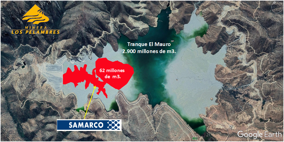
Figure 5. El Mauro – Bento Rodrigues surface comparison. Own elaboration.
The following figure shows the proportions of the land affected by the collapse of Bento Rodrigues, compared to the size of the land that would be covered by the collapse of the El Mauro dam from the dam wall to Los Vilos.
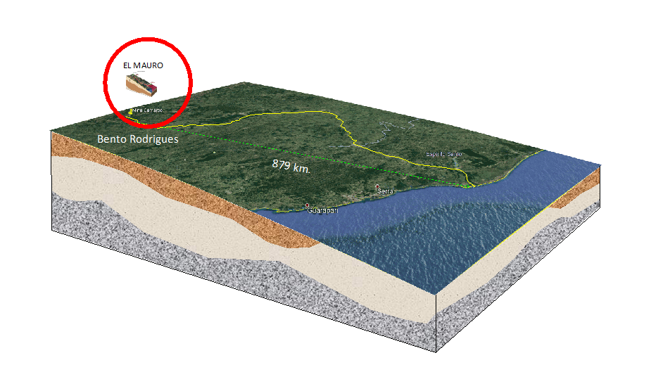
Figure 6. Bento Rodrigues tailings route vs. El Mauro tailings.
We emphasise that to make a valid safety plan, it is necessary to take as a baseline the total collapse of the dam at its moment of greatest tailings content, that is, the worst possible case.
We have recommended to the Municipality and the community of Caimanes that they require the Los Pelambres mining company to commission a computerised simulation, with the best current technology, by an independent company that guarantees that the result is true to reality, not like the plans delivered by the mining company that do not meet the minimum standard.
An example of this type of simulation can be seen at the following link: https://www.youtube.com/watch?v=CVQCK6idFWQ&ab_channel=E8IGHT%7C%EC%9D%B4%EC%97%90%EC%9D%B4%ED%8A%B8
This is a very relevant and highly serious matter. It was not discussed in the session, but arose as a result of the data exposed above.
In the case of collapse of the dam, the tailings will run downstream following the course of the Pupío estuary, affecting fields, houses and infrastructure such as roads. Highway D-865, which connects Caimanes with Los Vilos, runs alongside the river and will suffer severe damage, in which case the only access for fire trucks will be from the south, as illustrated in the following figure.

Figure 7. Access to Caimanes post collapse.
Fire trucks trying to access via D-37-E will be blocked in the four metre Las Palmas tunnel. wide, which only fits small vehicles. The only alternative from Los Vilos and from Santiago would be to arrive via Route 5, and then take the D-875 road. But when taking the D-37-E road, towards Caimanes, they will find the metal bridge over which the large fire trucks do not fit. The smaller vehicles that manage to pass will find that before reaching Caimanes the bridge will have been destroyed by the tailings.
None of this was reported by Los Pelambres mining company. SERNAGEOMIN, ONEMI and firefighters, who had to review the Emergency Plan before agreeing to take charge of its application, were overlooked.
Following the presentation of the events described above, Esteban Vilches, a lawyer for the Caimanes and Valle de Pupío Defence Committee, intervened, pointing out that the emergency plan had been ordered by the Supreme Court in the 2014 ruling, and, like other mining commitments, it was many years behind schedule.
Next, Jan Morrill, Coordinator of the Tailings Campaign of the Earthworks organisation, intervened. She pointed out the need for the mining company to adopt the best international practices, and confirmed that it is necessary to carry out a simulation by an independent and competent body.
After the exhibition, residents of Caimanes intervened, and the representative of the Fire Department promised to review the background again. The Los Pelambres mining manager did not refute any of the information presented, stating that they work with the “highest standards”.
Finally, the Municipal Council decided to go ahead with the plan, with the Chilean Fire Department in charge of it, and ask the mining company to carry out and deliver a simulation with the most modern technology available.
Given the evidence, two scenarios open up:
1) Pelambres, ONEMI and SERNAGEMIN do not have the necessary skills to assess the real risk of the collapse of a dam like El Mauro.
2) If they do have the skills, the company and these institutions for some reason do not do the work they are required to do.
In both cases, Chile has serious problems with tailings dams.